IMAGES TAKEN NEAR TO
The Laurels, Railway Street, BRAINTREE, CM7 3JS
Introduction
This page details the photographs taken nearby to The Laurels, Railway Street, CM7 3JS by members of the Geograph project.
The Geograph project started in 2005 with the aim of publishing, organising and preserving representative images for every square kilometre of Great Britain, Ireland and the Isle of Man.

There are currently over 7.5m images from over14,400 individuals and you can help contribute to the project by visiting https://www.geograph.org.uk
Image Map (Loading...)


Getting Data...Please wait
Leaflet Map data © OpenStreetMap
Images are licensed for reuse under creativecommons.org/licenses/by-sa/2.0
Notes
- Clicking on the map will re-center to the selected point.
- The higher the marker number, the further away the image location is from the centre of the postcode.
Image Listing (53 Images Found)
Images are licensed for reuse under creativecommons.org/licenses/by-sa/2.0
Image
Details
Distance
1
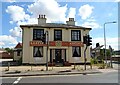
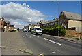
Eastern Aroma Restaurant, Braintree
On Railway Street.
Image: © JThomas
Taken: 24 Aug 2022
0.03 miles
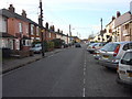
4
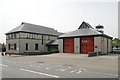
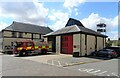
Braintree fire station
Braintree fire station, Railway Street, Braintree, Essex
Image: © Kevin Hale
Taken: 5 Jun 2010
0.04 miles
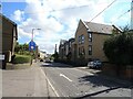
5
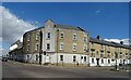
Railway Street, Braintree
Looking north on the B1256.
Image: © JThomas
Taken: 24 Aug 2022
0.06 miles
9
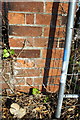
Benchmark on corner wall pier in Station Approach
Ordnance Survey cut mark benchmark described on the Bench Mark Database at http://www.bench-marks.org.uk/bm37768
Image: © Roger Templeman
Taken: 30 Apr 2011
0.14 miles
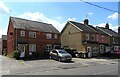
10
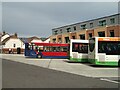
Braintree bus interchange
Opened January 2022
Image: © John Myers
Taken: 13 Sep 2022
0.16 miles