IMAGES TAKEN NEAR TO
Coopers Park, Cooper Drive, BRAINTREE, CM7 2TN
Introduction
This page details the photographs taken nearby to Coopers Park, Cooper Drive, CM7 2TN by members of the Geograph project.
The Geograph project started in 2005 with the aim of publishing, organising and preserving representative images for every square kilometre of Great Britain, Ireland and the Isle of Man.

There are currently over 7.5m images from over14,400 individuals and you can help contribute to the project by visiting https://www.geograph.org.uk
Image Map (Loading...)


Getting Data...Please wait
Leaflet Map data © OpenStreetMap
Images are licensed for reuse under creativecommons.org/licenses/by-sa/2.0
Notes
- Clicking on the map will re-center to the selected point.
- The higher the marker number, the further away the image location is from the centre of the postcode.
Image Listing (4 Images Found)
Images are licensed for reuse under creativecommons.org/licenses/by-sa/2.0
Image
Details
Distance
1
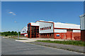
The College at Braintree - Construction
An industrial estate building for the construction department of the college.
Image: © Robin Webster
Taken: 27 May 2013
0.06 miles
2
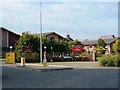
Tabor Science College/Braintree Leisure Centre, Braintree
The previously named Tabor High School, Panfield Lane, shares its facilities with the leisure centre.
Image: © Brenda Howard
Taken: 2 Oct 2005
0.17 miles
3
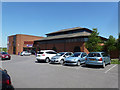
Xpect health and fitness
This club does not seem to be part of a chain, only this Braintree establishment exists.
Image: © Robin Webster
Taken: 27 May 2013
0.17 miles
4
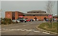
Part of Springwood Industrial Estate
Image: © Robert Edwards
Taken: 13 Apr 2007
0.18 miles