IMAGES TAKEN NEAR TO
Nottage Crescent, BRAINTREE, CM7 2TF
Introduction
This page details the photographs taken nearby to Nottage Crescent, CM7 2TF by members of the Geograph project.
The Geograph project started in 2005 with the aim of publishing, organising and preserving representative images for every square kilometre of Great Britain, Ireland and the Isle of Man.

There are currently over 7.5m images from over14,400 individuals and you can help contribute to the project by visiting https://www.geograph.org.uk
Image Map
Images are licensed for reuse under creativecommons.org/licenses/by-sa/2.0
Notes
- Clicking on the map will re-center to the selected point.
- The higher the marker number, the further away the image location is from the centre of the postcode.
Image Listing (10 Images Found)
Images are licensed for reuse under creativecommons.org/licenses/by-sa/2.0
Image
Details
Distance
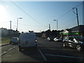
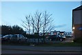
1
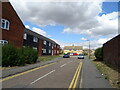
Peel Crescent, Braintree
Off Rayne Road (B1256).
Image: © JThomas
Taken: 24 Aug 2022
0.06 miles
4
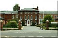
St. Michael's Hospital, Braintree, Essex
Image: © Robert Edwards
Taken: 23 Aug 2006
0.11 miles
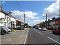
5
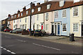
Rayne Road, Braintree
Colourful houses on the north side of Rayne Road close to the town centre.
Image: © Stephen McKay
Taken: 31 Oct 2017
0.14 miles
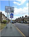
7
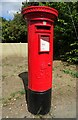
George V postbox on Rayne Road, Braintree
Postbox No. CM7 67.
Image: © JThomas
Taken: 24 Aug 2022
0.21 miles
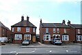
9
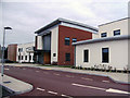
Community Hospital, Braintree, Essex
St Michael's Hospital has been demolished and is now a housing development. This is the new Community Hospital.
Image: © Peter Stack
Taken: 9 Sep 2010
0.23 miles