IMAGES TAKEN NEAR TO
Marshalls Drive, BRAINTREE, CM7 2LN
Introduction
This page details the photographs taken nearby to Marshalls Drive, CM7 2LN by members of the Geograph project.
The Geograph project started in 2005 with the aim of publishing, organising and preserving representative images for every square kilometre of Great Britain, Ireland and the Isle of Man.

There are currently over 7.5m images from over14,400 individuals and you can help contribute to the project by visiting https://www.geograph.org.uk
Image Map (Loading...)


Getting Data...Please wait
Leaflet Map data © OpenStreetMap
Images are licensed for reuse under creativecommons.org/licenses/by-sa/2.0
Notes
- Clicking on the map will re-center to the selected point.
- The higher the marker number, the further away the image location is from the centre of the postcode.
Image Listing (2 Images Found)
Images are licensed for reuse under creativecommons.org/licenses/by-sa/2.0
Image
Details
Distance
1
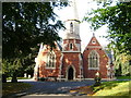
Chapel in Cemetery, London Road, Braintree
The cemetery is situated in London Road, north of the A120 by-pass.
Image: © Brenda Howard
Taken: 9 Oct 2005
0.11 miles
2
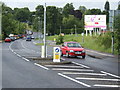
Braintree expands
Another tranche of land is opened up for housing just off the London Road south of the town. The road to the right leads into an estate with road names such as Tortoiseshell, Grayling and Comma; indicating a meadowland past for this land next to the river Brain.
Image: © Jonathan Billinger
Taken: 30 May 2007
0.21 miles