IMAGES TAKEN NEAR TO
Badger Mount, BRAINTREE, CM7 2DE
Introduction
This page details the photographs taken nearby to Badger Mount, CM7 2DE by members of the Geograph project.
The Geograph project started in 2005 with the aim of publishing, organising and preserving representative images for every square kilometre of Great Britain, Ireland and the Isle of Man.

There are currently over 7.5m images from over14,400 individuals and you can help contribute to the project by visiting https://www.geograph.org.uk
Image Map
Images are licensed for reuse under creativecommons.org/licenses/by-sa/2.0
Notes
- Clicking on the map will re-center to the selected point.
- The higher the marker number, the further away the image location is from the centre of the postcode.
Image Listing (4 Images Found)
Images are licensed for reuse under creativecommons.org/licenses/by-sa/2.0
Image
Details
Distance
3
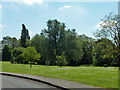
Open space by Brook Close
The 'brook' is the River Brain, although brook-sized here. It runs along the right margin of the grass.
Image: © Robin Webster
Taken: 27 May 2013
0.24 miles
4
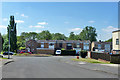
Houses on Nayling Road, Braintree
An enlargement of the town to the west.
Image: © Robin Webster
Taken: 27 May 2013
0.25 miles