IMAGES TAKEN NEAR TO
Legg Close, CM7 2BP
Introduction
This page details the photographs taken nearby to Legg Close, CM7 2BP by members of the Geograph project.
The Geograph project started in 2005 with the aim of publishing, organising and preserving representative images for every square kilometre of Great Britain, Ireland and the Isle of Man.

There are currently over 7.5m images from over14,400 individuals and you can help contribute to the project by visiting https://www.geograph.org.uk
Image Map
Images are licensed for reuse under creativecommons.org/licenses/by-sa/2.0
Notes
- Clicking on the map will re-center to the selected point.
- The higher the marker number, the further away the image location is from the centre of the postcode.
Image Listing (7 Images Found)
Images are licensed for reuse under creativecommons.org/licenses/by-sa/2.0
Image
Details
Distance
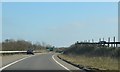
1
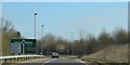
Approaching roundabout, slip road off the A120
Image: © N Chadwick
Taken: 13 Mar 2016
0.11 miles
3
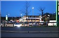
Notley Cross Services
I bought a bottle of milk and a TV guide and went for a tinkle.
Image: © David Howard
Taken: 14 Mar 2019
0.17 miles

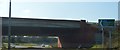
7
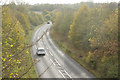
Pod's Brook Road, Braintree
Seen from the Flitch Way, Pod's Brook Road - or the B1256 - curves gently towards its junction with the A120.
Image: © Stephen McKay
Taken: 31 Oct 2017
0.23 miles