IMAGES TAKEN NEAR TO
The Pines, New Street, BRAINTREE, CM7 1XT
Introduction
This page details the photographs taken nearby to The Pines, New Street, CM7 1XT by members of the Geograph project.
The Geograph project started in 2005 with the aim of publishing, organising and preserving representative images for every square kilometre of Great Britain, Ireland and the Isle of Man.

There are currently over 7.5m images from over14,400 individuals and you can help contribute to the project by visiting https://www.geograph.org.uk
Image Map
Images are licensed for reuse under creativecommons.org/licenses/by-sa/2.0
Notes
- Clicking on the map will re-center to the selected point.
- The higher the marker number, the further away the image location is from the centre of the postcode.
Image Listing (98 Images Found)
Images are licensed for reuse under creativecommons.org/licenses/by-sa/2.0
Image
Details
Distance
1
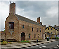
"Leahurst", Braintree
Former nurses home, the gift of William Julien Courtauld. Built in 1939 to a design by architect Vincent Harris, There is a small statue above the entrance door by Eric Gill. Grade II listed: description at this https://historicengland.org.uk/listing/the-list/list-entry/1393768.
Image: © Jim Osley
Taken: 6 May 2017
0.02 miles
2
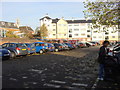
South Street, Braintree
Junction with St Michael's Lane.
Image: © JThomas
Taken: 24 Aug 2022
0.03 miles
3
Braintree Cage
This is a Victorian lock up it was used from 1840 to 1875 for the holding of those deemed drunk and disorderly.
Image: © Glyn Baker
Taken: 13 Jun 2019
0.03 miles
4
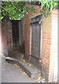
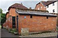
Braintree Cage (Parish Lock-up), Hilly Gant, off New Street
Drunkenness and disorder associated with market days and Braintree's October fair was already a significant problem, when in 1830 the very liberal Beer Act resulted in around thirty beerhouses opening in the town with the predictable result. Power returned to local magistrates in 1869 but by then the law already required overnight accommodation - a lock-up or cage - for the restraint of the drunk and disorderly.
Built sometime after 1840, it appears on the 1878 Ordnance Survey map. The Braintree Cage was approached from Hilly Gant ("gant" being a local term for passage) which linked St. Michael's Lane with New Street. New Street was notorious at the time with four pubs, three of which were known colloquially as "Little Hell", "Great Hell" and "Damnation". The Cage is constructed of red clay brick with a lean-to slated roof and measures 16 feet by 6 feet (4.9m x 1.8m) and divided internally into two cells. The padlocked outer door, shown in this image, pre-dates the building by as much as 200 years and is reputed to have been removed from the earlier watchhouse or lock-up in the Old Workhouse (located nearby on the current site of Tesco's supermarket). The construction of the Cage cost £45 5s 0d (£45.25), the land having been purchased in 1840 for £30.
The cage remained in use until 1875, and was thereafter let to the 12th Essex Volunteer Rifles (a forerunner of local Territorial Army units) for the sum of ten shillings (£0.50) per annum for use as an ammunition store. Braintree Urban District Council purchased the Cage in 1899 and use as an ammunition store ceases in 1911. It was then neglected until 1977 when it received Grade II Listed status and in 1982 Braintree & Bocking Civic Society undertook to repair the roof and provide a path to the site.
The above has been abstracted from "Braintree Cage in its social and historical setting" written by Michael Bardwell on behalf of Braintree & Bocking Civic Society. ISBN 0-9547-490-0-6 available from the shop at Braintree District Museum: http://www.braintree.gov.uk/Braintree/leisure-culture/BDMS/Museum/
For a view of Hilly Gant from the St. Michael's Lane end see:
Image
Image: © Trevor Wright
Taken: 23 Jul 2009
0.03 miles
5
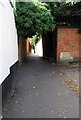
Hilly Gant and Braintree Cage, New Street, Braintree
Hilly Gant ("gant" being a local term for passage) links New Street with St. Michaels Lane in the distance.
The brick structure to the right hidden in shadow under the tree is the "Braintree Cage" or Parish Lock-up.
This was used from around 1840 to 1875 to house those guilty of being drunk or disorderly.
For a closer view of the Cage and further historical details see:
Image
and for a view of Hilly Gant from the St. Michaels Lane aspect see:
Image
Image: © Trevor Wright
Taken: 23 Jul 2009
0.03 miles
7

Hilly Gant, Braintree, linking St. Michaels Lane with New Street
A "Gant" is a local term for a passageway. At the far/top end of Hilly Gant is the "Braintree Cage", the old parish lockup for drunks.
For a closer view of the Cage and further historical details see:
Image
and for a view of Hilly Gant from the St. Michaels Lane aspect see:
Image
Also see:
Image
Image: © Trevor Wright
Taken: 23 Jul 2009
0.04 miles
8

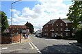
St. Michaels Lane, looking towards junction with High Street, Braintree
A view along half of St Michaels Lane. On the right is a Dental Surgery, the rear access to High Street shops, a pair of semi-detached Town Houses and the Vestry Hall. On the left the wall borders the Churchyard of St. Michaels Church.
The other half of St. Michaels Lane is available here:
Image
Image: © Trevor Wright
Taken: 23 Jul 2009
0.04 miles
9

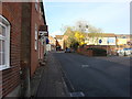
St. Michaels Lane, looking towards junction with St. Michaels Road and Notley Road, Braintree
A view of half of St. Michaels Lane. On the right the wall borders the Churchyard of St. Michaels Church. On the left, between where the second part of the brick wall ends and the telegraph pole, is the entry to "Hilly Gant". A "Gant" is a local term for a passageway and links through to New Street. At the far/top end of Hilly Gant is the "Braintree Cage", the old parish lockup for drunks.
The other half of St. Michaels Lane is available here:
Image
Image: © Trevor Wright
Taken: 23 Jul 2009
0.05 miles