IMAGES TAKEN NEAR TO
Harrison Drive, BRAINTREE, CM7 1DE
Introduction
This page details the photographs taken nearby to Harrison Drive, CM7 1DE by members of the Geograph project.
The Geograph project started in 2005 with the aim of publishing, organising and preserving representative images for every square kilometre of Great Britain, Ireland and the Isle of Man.

There are currently over 7.5m images from over14,400 individuals and you can help contribute to the project by visiting https://www.geograph.org.uk
Image Map (Loading...)


Getting Data...Please wait
Leaflet Map data © OpenStreetMap
Images are licensed for reuse under creativecommons.org/licenses/by-sa/2.0
Notes
- Clicking on the map will re-center to the selected point.
- The higher the marker number, the further away the image location is from the centre of the postcode.
Image Listing (4 Images Found)
Images are licensed for reuse under creativecommons.org/licenses/by-sa/2.0
Image
Details
Distance
1
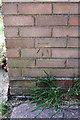
Benchmark on the garage extension of #105 Challis Lane
Ordnance Survey cut mark benchmark described on the Bench Mark Database at http://www.bench-marks.org.uk/bm37789
Image: © Roger Templeman
Taken: 30 Apr 2011
0.07 miles
2

New housing, Braintree
Extensive filling in of greenfield sites north of the A120 bypass, which is still going on further south. The low-lying strip along the River Brain valley is being left green amenity land. West facing windows should have a splendid view over the local sewage works.
Image: © Robin Webster
Taken: 27 May 2013
0.12 miles
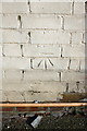
3

Benchmark on #51 Duggers Lane
Ordnance Survey cut mark benchmark described on the Bench Mark Database at http://www.bench-marks.org.uk/bm37788
Image: © Roger Templeman
Taken: 30 Apr 2011
0.15 miles
4
Benchmark on the side of #21 Duggers Lane
Ordnance Survey cut mark benchmark described on the Bench Mark Database at http://www.bench-marks.org.uk/bm37787
Image: © Roger Templeman
Taken: 30 Apr 2011
0.20 miles