IMAGES TAKEN NEAR TO
Goldingham Drive, BRAINTREE, CM7 1DD
Introduction
This page details the photographs taken nearby to Goldingham Drive, CM7 1DD by members of the Geograph project.
The Geograph project started in 2005 with the aim of publishing, organising and preserving representative images for every square kilometre of Great Britain, Ireland and the Isle of Man.

There are currently over 7.5m images from over14,400 individuals and you can help contribute to the project by visiting https://www.geograph.org.uk
Image Map
Images are licensed for reuse under creativecommons.org/licenses/by-sa/2.0
Notes
- Clicking on the map will re-center to the selected point.
- The higher the marker number, the further away the image location is from the centre of the postcode.
Image Listing (7 Images Found)
Images are licensed for reuse under creativecommons.org/licenses/by-sa/2.0
Image
Details
Distance

2
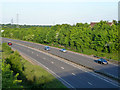
A120 at Notley Road bridge
A southern bypass of Braintree.
Image: © Robin Webster
Taken: 27 May 2013
0.16 miles
3
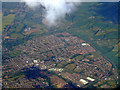
Braintree from the air
The east end of Braintree, viewed from a Prague bound flight from Stansted.
Image: © Thomas Nugent
Taken: 9 May 2011
0.18 miles

5
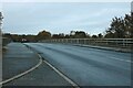
Notley Bridge over the A120, Braintree
Image: © David Howard
Taken: 12 Nov 2023
0.22 miles
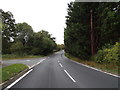
6
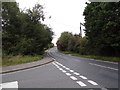
Witham Road, Black Notley
At the junction with Buck Hill
Road No.C189
Image: © Geographer
Taken: 10 Oct 2019
0.23 miles
7
Witham Road, Black Notley
At the junction with Buck Hill
Road No.C189
Image: © Geographer
Taken: 10 Oct 2019
0.24 miles