IMAGES TAKEN NEAR TO
Hyacinth Drive, CM6 4FU
Introduction
This page details the photographs taken nearby to Hyacinth Drive, CM6 4FU by members of the Geograph project.
The Geograph project started in 2005 with the aim of publishing, organising and preserving representative images for every square kilometre of Great Britain, Ireland and the Isle of Man.

There are currently over 7.5m images from over14,400 individuals and you can help contribute to the project by visiting https://www.geograph.org.uk
Image Map
Images are licensed for reuse under creativecommons.org/licenses/by-sa/2.0
Notes
- Clicking on the map will re-center to the selected point.
- The higher the marker number, the further away the image location is from the centre of the postcode.
Image Listing (7 Images Found)
Images are licensed for reuse under creativecommons.org/licenses/by-sa/2.0
Image
Details
Distance
1
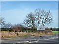
Welcome to Great Dunmow
A sign on the town limits. The road here is the course of the Roman Stane Street towards Colchester.
Image: © Robin Webster
Taken: 11 Jan 2015
0.10 miles
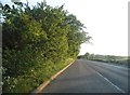
3
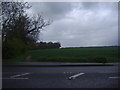
Stortford Road, Great Dunmow
This is part of the original Roman road, Stane Street
Image: © David Howard
Taken: 25 Apr 2012
0.11 miles
6
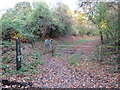
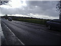
Flitch Way, near Great Dunmow
A gate on the Flitch Way near the town of Great Dunmow. The gate prevents motor vehicles from using the path.
Image: © Malc McDonald
Taken: 29 Oct 2022
0.19 miles
7
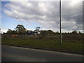
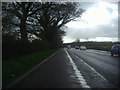
Dunmow Fencing Supplies on Stortford Road
Image: © David Howard
Taken: 18 Apr 2017
0.23 miles