IMAGES TAKEN NEAR TO
Mount Fields, DUNMOW, CM6 3XH
Introduction
This page details the photographs taken nearby to Mount Fields, CM6 3XH by members of the Geograph project.
The Geograph project started in 2005 with the aim of publishing, organising and preserving representative images for every square kilometre of Great Britain, Ireland and the Isle of Man.

There are currently over 7.5m images from over14,400 individuals and you can help contribute to the project by visiting https://www.geograph.org.uk
Image Map
Images are licensed for reuse under creativecommons.org/licenses/by-sa/2.0
Notes
- Clicking on the map will re-center to the selected point.
- The higher the marker number, the further away the image location is from the centre of the postcode.
Image Listing (17 Images Found)
Images are licensed for reuse under creativecommons.org/licenses/by-sa/2.0
Image
Details
Distance
1
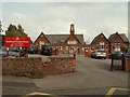
Stebbing Primary School, Stebbing, Essex
Image: © Robert Edwards
Taken: 13 Sep 2006
0.09 miles
2

Reserve Sign
One of the signs indicating Stebbing has an Image
Image: © Glyn Baker
Taken: 22 Sep 2007
0.09 miles
3
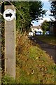
Eco Verge
The post indicates the verge is a nature reserve in Stebbing Essex see a closeup of the Image here.
Image: © Glyn Baker
Taken: 22 Sep 2007
0.09 miles

5
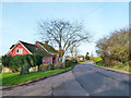
Road towards Bran End, Stebbing
The ancient looking stone on the left seems to be a recent planting, perhaps to deter vehicles pulling onto the grass.
Image: © Robin Webster
Taken: 11 Jan 2015
0.12 miles
6
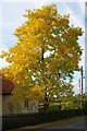
Signs of Autumn
This is a close up of the tree in picture Image
Image: © Glyn Baker
Taken: 22 Sep 2007
0.14 miles
7
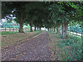
Driveway to Stebbing Park
For further information on the background of Stebbing Park see this PDF from Essex County Council Field Archaeology Unit http://archaeologydataservice.ac.uk/catalogue/adsdata/arch-439-1/dissemination/pdf/essexcou1-65357_1.pdf
Image: © Roger Jones
Taken: 15 Aug 2013
0.15 miles
8
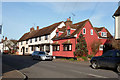
Houses on Stebbing High Street
The far two light coloured buildings are grade II listed. The oldest parts of the timbered building are 15th century.
Image: © Robin Webster
Taken: 11 Jan 2015
0.16 miles
9
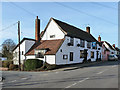
The White Hart, Stebbing
A grade II listed building, 17th century and earlier, on the west side of the High Street.
Image: © Robin Webster
Taken: 11 Jan 2015
0.17 miles
10
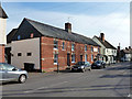
Houses on Stebbing High Street
The brick row and the house beyond are grade II listed buildings. The far house is of Town Farm, 16th century. The brick row has 19th century brickwork over probably a 17th century core. Bell House, this end, was originally a pub. The far end was at some stage a butchers, which accounts for the bay frontage and the light rectangle, now unlettered.
Image: © Robin Webster
Taken: 11 Jan 2015
0.18 miles