IMAGES TAKEN NEAR TO
Dunmow Road, DUNMOW, CM6 3XD
Introduction
This page details the photographs taken nearby to Dunmow Road, CM6 3XD by members of the Geograph project.
The Geograph project started in 2005 with the aim of publishing, organising and preserving representative images for every square kilometre of Great Britain, Ireland and the Isle of Man.

There are currently over 7.5m images from over14,400 individuals and you can help contribute to the project by visiting https://www.geograph.org.uk
Image Map
Images are licensed for reuse under creativecommons.org/licenses/by-sa/2.0
Notes
- Clicking on the map will re-center to the selected point.
- The higher the marker number, the further away the image location is from the centre of the postcode.
Image Listing (3 Images Found)
Images are licensed for reuse under creativecommons.org/licenses/by-sa/2.0
Image
Details
Distance
1
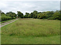
Onslow Green
The green is managed as a nature reserve. Onslow Green was known as Hounslow Green not so long ago.
Image: © Robin Webster
Taken: 8 Sep 2011
0.24 miles
2
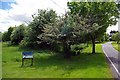
Onslow Green
Onslow Village green was formerly managed managed as a nature reserve by Essex Wildlife Trust http://www.essexwt.org.uk/ it is now in the care of Barnston Counxcil. See another view at Image or You can embark on a virtual tour of the vast majority of Wildlife Trust Reserves in and around Essex by visiting Image
Image: © Glyn Baker
Taken: 17 May 2009
0.24 miles
3
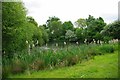
Onslow Pond
This is the pond on Onslow Village green it is a nature reserve formerly managed by Essex Wildlife Trust http://www.essexwt.org.uk/ Now in the care of Barnston Council.
Image: © Glyn Baker
Taken: 17 May 2009
0.24 miles