IMAGES TAKEN NEAR TO
Collops Road, DUNMOW, CM6 3SZ
Introduction
This page details the photographs taken nearby to Collops Road, CM6 3SZ by members of the Geograph project.
The Geograph project started in 2005 with the aim of publishing, organising and preserving representative images for every square kilometre of Great Britain, Ireland and the Isle of Man.

There are currently over 7.5m images from over14,400 individuals and you can help contribute to the project by visiting https://www.geograph.org.uk
Image Map
Images are licensed for reuse under creativecommons.org/licenses/by-sa/2.0
Notes
- Clicking on the map will re-center to the selected point.
- The higher the marker number, the further away the image location is from the centre of the postcode.
Image Listing (5 Images Found)
Images are licensed for reuse under creativecommons.org/licenses/by-sa/2.0
Image
Details
Distance
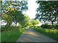
1
Collops Road at the junction of New Pasture Lane
Image: © David Howard
Taken: 6 Jun 2013
0.18 miles
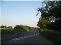
2
Road junction by Cowlands Farm
Felsted right, Great Saling left, with a weeping willow on the grass triangle.
Image: © Robin Webster
Taken: 30 Dec 2014
0.19 miles
3
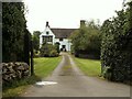
Porter's Hall, near Stebbing, Essex
This hall is at least 400 years old and surrounded by a moat.
Image: © Robert Edwards
Taken: 13 Sep 2006
0.22 miles