IMAGES TAKEN NEAR TO
The Downs, DUNMOW, CM6 3RF
Introduction
This page details the photographs taken nearby to The Downs, CM6 3RF by members of the Geograph project.
The Geograph project started in 2005 with the aim of publishing, organising and preserving representative images for every square kilometre of Great Britain, Ireland and the Isle of Man.

There are currently over 7.5m images from over14,400 individuals and you can help contribute to the project by visiting https://www.geograph.org.uk
Image Map
Images are licensed for reuse under creativecommons.org/licenses/by-sa/2.0
Notes
- Clicking on the map will re-center to the selected point.
- The higher the marker number, the further away the image location is from the centre of the postcode.
Image Listing (6 Images Found)
Images are licensed for reuse under creativecommons.org/licenses/by-sa/2.0
Image
Details
Distance
1
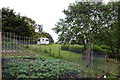
Allotments at Bran End
On Brick Kiln Lane.
Image: © Trevor Harris
Taken: 12 Jun 2016
0.07 miles
2
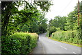
High Street, Stebbing
North of the main village approaching Bran End.
Image: © Trevor Harris
Taken: 12 Jun 2016
0.15 miles
3
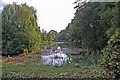
Pond in Stebbing
The owner of this pond in Stebbing High St has kindly cut notches in the hedge so the villagers can enjoy views of the water.
Image: © Glyn Baker
Taken: 22 Sep 2007
0.15 miles
4
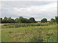
Field and paddocks near Blueitts Farm, Stebbing Bran End
As seen from the byway that runs between Bran End and Bardfield Saling, the field in the foreground looks a little under-managed, but nearby are a number of fenced off paddocks.
Image: © Roger Jones
Taken: 15 Aug 2013
0.18 miles
5
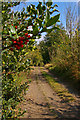
The Holly And The Byway
This is the byway from Bran End, Stebbing to Bardfield Saling.
Image: © Glyn Baker
Taken: 22 Sep 2007
0.24 miles
6
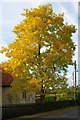
Signs of Autumn
This is a close up of the tree in picture Image
Image: © Glyn Baker
Taken: 22 Sep 2007
0.24 miles