IMAGES TAKEN NEAR TO
Bustard Green, DUNMOW, CM6 3QP
Introduction
This page details the photographs taken nearby to Bustard Green, CM6 3QP by members of the Geograph project.
The Geograph project started in 2005 with the aim of publishing, organising and preserving representative images for every square kilometre of Great Britain, Ireland and the Isle of Man.

There are currently over 7.5m images from over14,400 individuals and you can help contribute to the project by visiting https://www.geograph.org.uk
Image Map
Images are licensed for reuse under creativecommons.org/licenses/by-sa/2.0
Notes
- Clicking on the map will re-center to the selected point.
- The higher the marker number, the further away the image location is from the centre of the postcode.
Image Listing (7 Images Found)
Images are licensed for reuse under creativecommons.org/licenses/by-sa/2.0
Image
Details
Distance
1
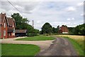
Bustard Green
The houses in this hamlet beside a byway stand around a long thin stretch of common land that is managed by the locals http://www.wildessex.net/sites/Bustard%20Green.htm
Image: © Glyn Baker
Taken: 10 Aug 2013
0.04 miles
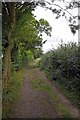
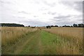
2
Bustard Green Byway
This byway runs through Bustard Green's common land
Image: © Glyn Baker
Taken: 10 Aug 2013
0.05 miles
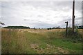
3
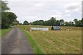
Common Grazing, Bustard Green
Image is a thin stretch of common land beside a byway
Image: © Glyn Baker
Taken: 10 Aug 2013
0.09 miles
4
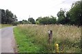
Verge Reserve Bustard Green
The sign indicates the grass verge in Image is a local nature reserve.
Image: © Glyn Baker
Taken: 10 Aug 2013
0.14 miles
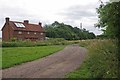
5
Towards Brazenhead Farm
This is the point where the Image leaves Daisyley Rd
Image: © Glyn Baker
Taken: 10 Aug 2013
0.19 miles
6
Bridleway to Brazenhead Farm
This footpath links Daisyley Rd with the B1057
Image: © Glyn Baker
Taken: 10 Aug 2013
0.20 miles