IMAGES TAKEN NEAR TO
Dunmow Road, DUNMOW, CM6 3QD
Introduction
This page details the photographs taken nearby to Dunmow Road, CM6 3QD by members of the Geograph project.
The Geograph project started in 2005 with the aim of publishing, organising and preserving representative images for every square kilometre of Great Britain, Ireland and the Isle of Man.

There are currently over 7.5m images from over14,400 individuals and you can help contribute to the project by visiting https://www.geograph.org.uk
Image Map
Images are licensed for reuse under creativecommons.org/licenses/by-sa/2.0
Notes
- Clicking on the map will re-center to the selected point.
- The higher the marker number, the further away the image location is from the centre of the postcode.
Image Listing (4 Images Found)
Images are licensed for reuse under creativecommons.org/licenses/by-sa/2.0
Image
Details
Distance
1
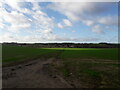
Footpath through a field near Thaxted
Photo is taken from Dunmow Road (B184) near Thaxted
Image: © Ola
Taken: 13 Jan 2023
0.10 miles
2
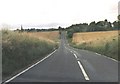
B184 approach to Thaxted
B road running through prime agricultural land.
Image: © Simon Davies
Taken: Unknown
0.11 miles
3
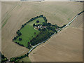
Prior's Hall from the air
An island of green, south of Thaxted. Viewed from a Stansted bound flight from Glasgow.
Image: © Thomas Nugent
Taken: 27 Sep 2016
0.18 miles
4
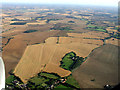
Essex from the air
Thaxted Bowls Club is visible at the bottom of the photo which was taken from a Stansted bound flight from Prague.
Image: © Thomas Nugent
Taken: 7 Sep 2012
0.21 miles