IMAGES TAKEN NEAR TO
Bennetts Lane, DUNMOW, CM6 3PG
Introduction
This page details the photographs taken nearby to Bennetts Lane, CM6 3PG by members of the Geograph project.
The Geograph project started in 2005 with the aim of publishing, organising and preserving representative images for every square kilometre of Great Britain, Ireland and the Isle of Man.

There are currently over 7.5m images from over14,400 individuals and you can help contribute to the project by visiting https://www.geograph.org.uk
Image Map
Images are licensed for reuse under creativecommons.org/licenses/by-sa/2.0
Notes
- Clicking on the map will re-center to the selected point.
- The higher the marker number, the further away the image location is from the centre of the postcode.
Image Listing (4 Images Found)
Images are licensed for reuse under creativecommons.org/licenses/by-sa/2.0
Image
Details
Distance
1
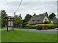
North End
The notice board is headed 'Great Waltham Parish Council'. Great Waltham village is a fair distance away, but it has a large parish, and North End is the north end of the parish.
Image: © Robin Webster
Taken: 8 Sep 2011
0.13 miles
3
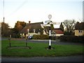
Signpost in North end
A new (dated 2004) signpost in traditional style in North End Hamlet.
Image: © John V Nicholls
Taken: 11 Jan 2006
0.14 miles