IMAGES TAKEN NEAR TO
Shepherds Hey, DUNMOW, CM6 3PD
Introduction
This page details the photographs taken nearby to Shepherds Hey, CM6 3PD by members of the Geograph project.
The Geograph project started in 2005 with the aim of publishing, organising and preserving representative images for every square kilometre of Great Britain, Ireland and the Isle of Man.

There are currently over 7.5m images from over14,400 individuals and you can help contribute to the project by visiting https://www.geograph.org.uk
Image Map
Images are licensed for reuse under creativecommons.org/licenses/by-sa/2.0
Notes
- Clicking on the map will re-center to the selected point.
- The higher the marker number, the further away the image location is from the centre of the postcode.
Image Listing (5 Images Found)
Images are licensed for reuse under creativecommons.org/licenses/by-sa/2.0
Image
Details
Distance
1
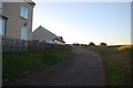
Footpath to Absol Park
The footpath, here following a lane called Shepherd's Hey and passing Gatehouses Cottages, leads on to Absol Park.
Image: © Trevor Harris
Taken: 11 Oct 2008
0.07 miles
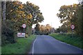
3
Absol Bridge
The bridge takes Mill Road over the River Chelmer.
Image: © Robin Webster
Taken: 8 Sep 2011
0.14 miles
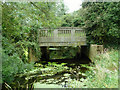
4
River Chelmer below Absol Bridge
It is noticeable how much less congested the channel is under the shade of trees where growth of water plants in inhibited. Trees bring their own blockage problems however, as may be seen.
Image: © Robin Webster
Taken: 8 Sep 2011
0.15 miles
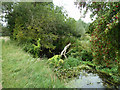
5
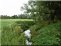
River Chelmer above Absol Bridge
It is not a very impressive river this far up, but it is probably at about minimum flow for the year and could do with some weed clearance.
Image: © Robin Webster
Taken: 8 Sep 2011
0.19 miles