IMAGES TAKEN NEAR TO
Parsonage Lane, DUNMOW, CM6 3NZ
Introduction
This page details the photographs taken nearby to Parsonage Lane, CM6 3NZ by members of the Geograph project.
The Geograph project started in 2005 with the aim of publishing, organising and preserving representative images for every square kilometre of Great Britain, Ireland and the Isle of Man.

There are currently over 7.5m images from over14,400 individuals and you can help contribute to the project by visiting https://www.geograph.org.uk
Image Map
Images are licensed for reuse under creativecommons.org/licenses/by-sa/2.0
Notes
- Clicking on the map will re-center to the selected point.
- The higher the marker number, the further away the image location is from the centre of the postcode.
Image Listing (18 Images Found)
Images are licensed for reuse under creativecommons.org/licenses/by-sa/2.0
Image
Details
Distance
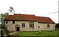
1
St Andrew, Barnston, Essex - Churchyard
Image: © John Salmon
Taken: 13 May 2009
0.07 miles
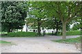
2
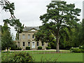
Barnston Lodge
Clearly not the gatehouse sort of lodge, this Georgian country house is now used as a wedding venue.
Image: © Robin Webster
Taken: 8 Sep 2011
0.08 miles
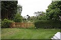
4
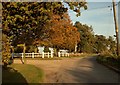
Part of Parsonage Lane just east of Barnston church
A public footpath leads off to the left.
Image: © Robert Edwards
Taken: 10 Oct 2008
0.09 miles
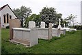
5
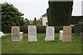
St Andrew, Barnston, Essex - Gravestones
Image: © John Salmon
Taken: 13 May 2009
0.10 miles
6
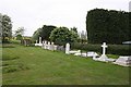
St Andrew, Barnston, Essex - Churchyard
Image: © John Salmon
Taken: 13 May 2009
0.10 miles
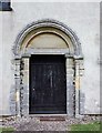
7
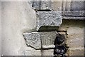
St Andrew, Barnston, Essex - Stonework on doorway
Image: © John Salmon
Taken: 13 May 2009
0.11 miles