IMAGES TAKEN NEAR TO
Chelmsford Road, DUNMOW, CM6 3NX
Introduction
This page details the photographs taken nearby to Chelmsford Road, CM6 3NX by members of the Geograph project.
The Geograph project started in 2005 with the aim of publishing, organising and preserving representative images for every square kilometre of Great Britain, Ireland and the Isle of Man.

There are currently over 7.5m images from over14,400 individuals and you can help contribute to the project by visiting https://www.geograph.org.uk
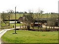
Image Map
Images are licensed for reuse under creativecommons.org/licenses/by-sa/2.0
Notes
- Clicking on the map will re-center to the selected point.
- The higher the marker number, the further away the image location is from the centre of the postcode.
Image Listing (3 Images Found)
Images are licensed for reuse under creativecommons.org/licenses/by-sa/2.0
Image
Details
Distance
1
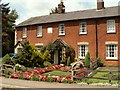
Victorian cottages at Barnston
These cottages stand by the junction where Parsonage Lane meets the A.130
Image: © Robert Edwards
Taken: 4 Jul 2007
0.03 miles
3
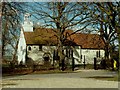
Parish church of Barnston, Essex
This is a Norman church with a 15th century belfry and 18th century cupola.
Image: © Robert Edwards
Taken: 1 Mar 2006
0.23 miles