IMAGES TAKEN NEAR TO
Cock Green, DUNMOW, CM6 3NT
Introduction
This page details the photographs taken nearby to Cock Green, CM6 3NT by members of the Geograph project.
The Geograph project started in 2005 with the aim of publishing, organising and preserving representative images for every square kilometre of Great Britain, Ireland and the Isle of Man.

There are currently over 7.5m images from over14,400 individuals and you can help contribute to the project by visiting https://www.geograph.org.uk
Image Map
Images are licensed for reuse under creativecommons.org/licenses/by-sa/2.0
Notes
- Clicking on the map will re-center to the selected point.
- The higher the marker number, the further away the image location is from the centre of the postcode.
Image Listing (4 Images Found)
Images are licensed for reuse under creativecommons.org/licenses/by-sa/2.0
Image
Details
Distance
1
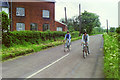
Cycling past the old mill, Cock Green, 1985
The really old mill at Cock Green was a windmill, demolished about 1916. The building at the left had meantime taken over, still within the triangle of lanes here. This is the back, the front is on the lane turning off where the signpost is. When the picture was taken it had been converted into dwellings, and so it remains.
Image: © Robin Webster
Taken: 27 May 1985
0.01 miles
2
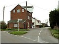
The Mill at Cock Green, near Felsted, Essex
This was once a working mill, but it has since been converted into living accommodation.
Image: © Robert Edwards
Taken: 26 Apr 2006
0.06 miles
3
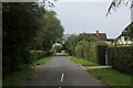
Cock Green
Causeway End Road heading through the hamlet of Cock Green
Image: © Chris Heaton
Taken: 18 Oct 2023
0.07 miles
4

Cock Green
Cock Green, Felsted a substantial house with its own sundial
Image: © Glyn Baker
Taken: 3 Sep 2005
0.10 miles