IMAGES TAKEN NEAR TO
Jollyboys Lane South, DUNMOW, CM6 3LR
Introduction
This page details the photographs taken nearby to Jollyboys Lane South, CM6 3LR by members of the Geograph project.
The Geograph project started in 2005 with the aim of publishing, organising and preserving representative images for every square kilometre of Great Britain, Ireland and the Isle of Man.

There are currently over 7.5m images from over14,400 individuals and you can help contribute to the project by visiting https://www.geograph.org.uk
Image Map
Images are licensed for reuse under creativecommons.org/licenses/by-sa/2.0
Notes
- Clicking on the map will re-center to the selected point.
- The higher the marker number, the further away the image location is from the centre of the postcode.
Image Listing (6 Images Found)
Images are licensed for reuse under creativecommons.org/licenses/by-sa/2.0
Image
Details
Distance
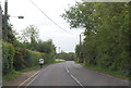
2
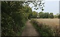
Jolleyboys Lane
This is a byway open to all traffic it runs from Cobblers Green to Causeway End.
Image: © Glyn Baker
Taken: 3 Sep 2005
0.12 miles
3
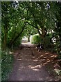
Bakers Lane
Lane is rather a grand name for this thoroughfare - more a well maintained footpath approaching Jollyboys.
Image: © Chris Heaton
Taken: 18 Oct 2023
0.17 miles
4
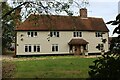
Jollyboys House
Grade II Listed building dating back to the 17th Century, with later alterations.
Image: © Chris Heaton
Taken: 18 Oct 2023
0.17 miles
5
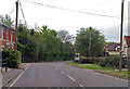
B1417 Chelmsford Road
Towards Causeway End.
Image: © Julian P Guffogg
Taken: 8 May 2015
0.20 miles
6
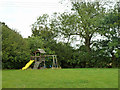
Play apparatus, Cobler's Green
It is not too clear if the field here is public or private. There is a house over the hedge on the left.
Image: © Robin Webster
Taken: 8 Sep 2011
0.25 miles