IMAGES TAKEN NEAR TO
Braintree Road, DUNMOW, CM6 3JZ
Introduction
This page details the photographs taken nearby to Braintree Road, CM6 3JZ by members of the Geograph project.
The Geograph project started in 2005 with the aim of publishing, organising and preserving representative images for every square kilometre of Great Britain, Ireland and the Isle of Man.

There are currently over 7.5m images from over14,400 individuals and you can help contribute to the project by visiting https://www.geograph.org.uk
Image Map
Images are licensed for reuse under creativecommons.org/licenses/by-sa/2.0
Notes
- Clicking on the map will re-center to the selected point.
- The higher the marker number, the further away the image location is from the centre of the postcode.
Image Listing (5 Images Found)
Images are licensed for reuse under creativecommons.org/licenses/by-sa/2.0
Image
Details
Distance
2
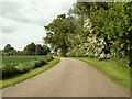
Gransmore Green, Essex
This place doesn't have a green as the name suggests. It is a dead-end road and this picture is taken from that end. It lies between Rayne and Felsted, just off the B1417.
Image: © Robert Edwards
Taken: 28 May 2006
0.15 miles
3
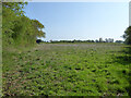
Uncultivated wedge end to field by Braintree Road
The rest of the field is growing oilseed rape. This corner was cultivated up to a few years ago, but not since.
Image: © Robin Webster
Taken: 24 Apr 2022
0.21 miles
4

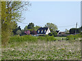
B1417 and Vintage Bus
The bus (a former London Routemaster) has just passed over a bridge crossing the former Bishop's Stortford to Braintree railway line, now part of the Flitch Way.
The bus was on a scheduled selected summer sunday service, linking Harlow to Braintree
Image: © Richard Thomas
Taken: 7 May 2006
0.23 miles
5
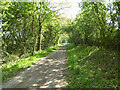
The Flitch Way east of Braintree Road bridge
Formerly the Bishop's Stortford - Witham line, but now abandoned west of Braintree. Much of this part is now a bridleway, also National Cycle Route 16.
Image: © Robin Webster
Taken: 24 Apr 2022
0.25 miles