IMAGES TAKEN NEAR TO
Pyes Bridge, DUNMOW, CM6 3JS
Introduction
This page details the photographs taken nearby to Pyes Bridge, CM6 3JS by members of the Geograph project.
The Geograph project started in 2005 with the aim of publishing, organising and preserving representative images for every square kilometre of Great Britain, Ireland and the Isle of Man.

There are currently over 7.5m images from over14,400 individuals and you can help contribute to the project by visiting https://www.geograph.org.uk
Image Map
Images are licensed for reuse under creativecommons.org/licenses/by-sa/2.0
Notes
- Clicking on the map will re-center to the selected point.
- The higher the marker number, the further away the image location is from the centre of the postcode.
Image Listing (2 Images Found)
Images are licensed for reuse under creativecommons.org/licenses/by-sa/2.0
Image
Details
Distance
1
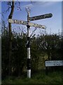
Direction Sign ? Signpost at Mole Hill Green, Felsted
Located at Mole Hill Green, on the southeast side of Rayne Road and Mole Hill Green Road, Felsted parish. 3 arms and annulus finial. Like the post in Felsted village https://www.geograph.org.uk/photo/6872276 this one has all the characteristics of one made by Stanton Ironworks such as the rounded ends to the arms, double ring moulding on the pillar and the elevated narrow annulus finial.
Milestone Society National ID: EX_TL7120
Image: © John V Nicholls
Taken: 28 Sep 2009
0.04 miles
2
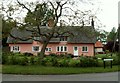
Pye's Farm Cottages, Molehill Green, Essex
Molehill Green lies south of Rayne near Braintree.
Image: © Robert Edwards
Taken: 28 May 2006
0.15 miles