IMAGES TAKEN NEAR TO
Station Road, DUNMOW, CM6 3HG
Introduction
This page details the photographs taken nearby to Station Road, CM6 3HG by members of the Geograph project.
The Geograph project started in 2005 with the aim of publishing, organising and preserving representative images for every square kilometre of Great Britain, Ireland and the Isle of Man.

There are currently over 7.5m images from over14,400 individuals and you can help contribute to the project by visiting https://www.geograph.org.uk
Image Map
Images are licensed for reuse under creativecommons.org/licenses/by-sa/2.0
Notes
- Clicking on the map will re-center to the selected point.
- The higher the marker number, the further away the image location is from the centre of the postcode.
Image Listing (4 Images Found)
Images are licensed for reuse under creativecommons.org/licenses/by-sa/2.0
Image
Details
Distance
1
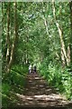
Walkers on the Flitch Way Near Felsted
The old railway is now an avenue of Ash trees approaching the old Felsted Station
Image: © Glyn Baker
Taken: 29 Jun 2019
0.09 miles
2
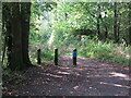
Bollards on the Flitch Way
The Flitch Way runs for 15 miles from Braintree station to Start Hill near Bishop's Stortford and is an important greenway and wildlife corridor. For most of the way it provides a safe traffic free environment for walkers, cyclists and horse riders and forms part of National Cycle Network Route 16. The name “Flitch Way” originated from the Flitch ceremony in Little Dunmow whereby couples who could prove that they had not argued in marriage after a year and a day would be awarded a flitch (side) of bacon. The Flitch Way follows the route of an old single track railway.
Image: © Geoff Holland
Taken: 19 Oct 2021
0.23 miles
4
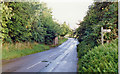
Site of Felsted station
View southward on Station Road past abutments of former bridge of ex-GER Bishop's Stortford (to right) - Braintree (to left) line, which closed to passengers 3/3/52, to goods 4/5/64; the station had been on the right.
Image: © Ben Brooksbank
Taken: 30 Aug 1992
0.25 miles