IMAGES TAKEN NEAR TO
Hallett Road, DUNMOW, CM6 3FY
Introduction
This page details the photographs taken nearby to Hallett Road, CM6 3FY by members of the Geograph project.
The Geograph project started in 2005 with the aim of publishing, organising and preserving representative images for every square kilometre of Great Britain, Ireland and the Isle of Man.

There are currently over 7.5m images from over14,400 individuals and you can help contribute to the project by visiting https://www.geograph.org.uk
Image Map
Images are licensed for reuse under creativecommons.org/licenses/by-sa/2.0
Notes
- Clicking on the map will re-center to the selected point.
- The higher the marker number, the further away the image location is from the centre of the postcode.
Image Listing (11 Images Found)
Images are licensed for reuse under creativecommons.org/licenses/by-sa/2.0
Image
Details
Distance
1

Bus Shelter on Station Road, Flitch Green
Image: © Chris Heaton
Taken: 18 Oct 2023
0.11 miles
2
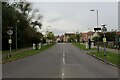
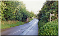
Hallett Road in Flitch Green
New development outside Little Dunmow, on the site of a demolished sugar beet factory
Image: © Chris Heaton
Taken: 18 Oct 2023
0.12 miles
3
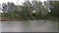
Pond near Priory Bridge, Flitch Green
People were fishing on this pond on the blowy October day this photo was taken.
Image: © Roger Jones
Taken: 27 Oct 2013
0.13 miles
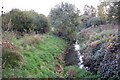
4

Station Road over Priory Bridge
Station Road crosses a tributary of the River Chelmer.
Image: © Julian P Guffogg
Taken: 8 May 2015
0.17 miles
5
The River Chelmer at Priory Bridge, Felsted
Image: © Trevor Harris
Taken: 11 Oct 2008
0.17 miles
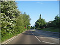
6

Houses on Baynard Avenue, Flitch Green
A 21st century civil parish built on the site of a sugar refinery, between Little Dunmow and Felsted.
Image: © Robin Webster
Taken: 7 Jun 2016
0.18 miles
8
Site of Felsted station
View southward on Station Road past abutments of former bridge of ex-GER Bishop's Stortford (to right) - Braintree (to left) line, which closed to passengers 3/3/52, to goods 4/5/64; the station had been on the right.
Image: © Ben Brooksbank
Taken: 30 Aug 1992
0.22 miles
9
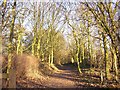
Flitch Way, Felsted
Looking east along the Flitch Way cycle and walking route on the former Dunmow to Braintree railway. Close by is Felsted Station house, now a private residence.
Image: © John V Nicholls
Taken: 11 Jan 2006
0.23 miles
10
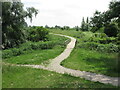
Footpath and Footbridge, Felsted Nature Area
In 2018 Felsted Parish Council took ownership of the open space area between Station Road, Felsted and Flitch Green with the object of developing and maintaining this space as a Nature Area. This footpath and footbridge, which stand close to edge of Flitch Green, lead into the Nature Area and give access to Station Road, Felsted.
Image: © Geoff Holland
Taken: 2 Jul 2021
0.24 miles