IMAGES TAKEN NEAR TO
Chelmsford Road, DUNMOW, CM6 3ET
Introduction
This page details the photographs taken nearby to Chelmsford Road, CM6 3ET by members of the Geograph project.
The Geograph project started in 2005 with the aim of publishing, organising and preserving representative images for every square kilometre of Great Britain, Ireland and the Isle of Man.

There are currently over 7.5m images from over14,400 individuals and you can help contribute to the project by visiting https://www.geograph.org.uk
Image Map
Images are licensed for reuse under creativecommons.org/licenses/by-sa/2.0
Notes
- Clicking on the map will re-center to the selected point.
- The higher the marker number, the further away the image location is from the centre of the postcode.
Image Listing (6 Images Found)
Images are licensed for reuse under creativecommons.org/licenses/by-sa/2.0
Image
Details
Distance
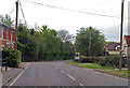
1
B1417 Chelmsford Road
Towards Causeway End.
Image: © Julian P Guffogg
Taken: 8 May 2015
0.03 miles
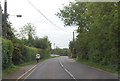
2
Bakers Lane byway (Causeway End)
This shows the madness of the law the B1417 (running right to left) where it would be safe to drive at 40mph there is a 30mph restriction. On the byway where 10mph would be reckless it is perfectly legal for some chump in a 4x4 or a trials bike to hack along at 60mph. Also on view is a fine example of a 1973 model Carlton Corsa 5 speed (one, not so careful owner).
Image: © Glyn Baker
Taken: 3 Sep 2005
0.04 miles
3
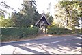
Felsted Congregationalist Burial Ground
The lychgate is the entrance to the burial ground.
Image: © Trevor Harris
Taken: 11 Oct 2008
0.05 miles
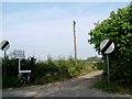
4
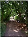
Jolleyboys Lane
This is a byway open to all traffic it runs from Cobblers Green to Causeway End.
Image: © Glyn Baker
Taken: 3 Sep 2005
0.22 miles
5
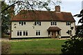
Jollyboys House
Grade II Listed building dating back to the 17th Century, with later alterations.
Image: © Chris Heaton
Taken: 18 Oct 2023
0.22 miles