IMAGES TAKEN NEAR TO
Braintree Road, DUNMOW, CM6 3DX
Introduction
This page details the photographs taken nearby to Braintree Road, CM6 3DX by members of the Geograph project.
The Geograph project started in 2005 with the aim of publishing, organising and preserving representative images for every square kilometre of Great Britain, Ireland and the Isle of Man.

There are currently over 7.5m images from over14,400 individuals and you can help contribute to the project by visiting https://www.geograph.org.uk
Image Map
Images are licensed for reuse under creativecommons.org/licenses/by-sa/2.0
Notes
- Clicking on the map will re-center to the selected point.
- The higher the marker number, the further away the image location is from the centre of the postcode.
Image Listing (6 Images Found)
Images are licensed for reuse under creativecommons.org/licenses/by-sa/2.0
Image
Details
Distance
1
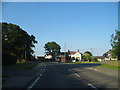
Braintree Road at the junction of Jollyboys Lane North
Image: © David Howard
Taken: 6 Jun 2013
0.11 miles
2
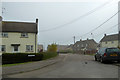
Chaffix, Felsted
A small estate that appears to have been built as council houses.
Image: © Robin Webster
Taken: 8 Apr 2017
0.14 miles
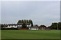
4
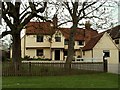
Garnett's House, Felsted, Essex
This is a good, well restored timber-framed building that stands along the main street of Felsted. Behind the house is the school cricket ground.
Image: © Robert Edwards
Taken: 26 Apr 2006
0.15 miles
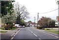
5
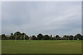
Felsted Preparatory School Playing Fields
Set up for the autumn term, which means rugby union.
Image: © Chris Heaton
Taken: 18 Oct 2023
0.20 miles
6
The Hunt Theatre, Felsted School
Wooden white building, which used to function as the school gymnasium
www.felsted.org
Image: © Chris Heaton
Taken: 18 Oct 2023
0.23 miles