IMAGES TAKEN NEAR TO
Duck End, DUNMOW, CM6 3BS
Introduction
This page details the photographs taken nearby to Duck End, CM6 3BS by members of the Geograph project.
The Geograph project started in 2005 with the aim of publishing, organising and preserving representative images for every square kilometre of Great Britain, Ireland and the Isle of Man.

There are currently over 7.5m images from over14,400 individuals and you can help contribute to the project by visiting https://www.geograph.org.uk
Image Map
Images are licensed for reuse under creativecommons.org/licenses/by-sa/2.0
Notes
- Clicking on the map will re-center to the selected point.
- The higher the marker number, the further away the image location is from the centre of the postcode.
Image Listing (5 Images Found)
Images are licensed for reuse under creativecommons.org/licenses/by-sa/2.0
Image
Details
Distance
1
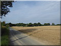
A lane near Lindsell
The B1057 is met where the woods can be seen in the distance.
Image: © Marathon
Taken: 26 Aug 2017
0.15 miles
2
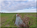
Field ditch near Hill Farm
It was slightly surprising to find a well-filled ditch on a slight terrace in the fields.
Image: © Robin Webster
Taken: 30 Dec 2014
0.18 miles
3
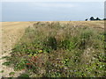
Field edge
Many of the hedgerows in East Anglia have been grubbed up as here, although a ditch with wild flowers remains to mark the line of where it was.
Image: © Marathon
Taken: 26 Aug 2017
0.19 miles
4
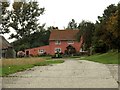
Farmhouse at Carter's Farm, near Lindsell, Essex
Image: © Robert Edwards
Taken: 13 Sep 2006
0.21 miles
5
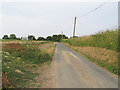
Rural road through arable land near Duck End, Stebbing
Image: © Roger Jones
Taken: 14 Jul 2013
0.22 miles