IMAGES TAKEN NEAR TO
Duck End, DUNMOW, CM6 3BP
Introduction
This page details the photographs taken nearby to Duck End, CM6 3BP by members of the Geograph project.
The Geograph project started in 2005 with the aim of publishing, organising and preserving representative images for every square kilometre of Great Britain, Ireland and the Isle of Man.

There are currently over 7.5m images from over14,400 individuals and you can help contribute to the project by visiting https://www.geograph.org.uk
Image Map
Images are licensed for reuse under creativecommons.org/licenses/by-sa/2.0
Notes
- Clicking on the map will re-center to the selected point.
- The higher the marker number, the further away the image location is from the centre of the postcode.
Image Listing (7 Images Found)
Images are licensed for reuse under creativecommons.org/licenses/by-sa/2.0
Image
Details
Distance
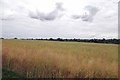
1
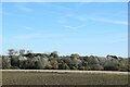
Autumn foliage on trees across Stebbing Brook
Looking towards Duck End from the path east of Lashley Hall.
Image: © Trevor Harris
Taken: 5 Nov 2021
0.07 miles
2
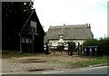
Duck End Forge and Forge Cottage, Essex
Duck End is on the B.1057 between Great Dunmow and Great Bardfield.
Image: © Robert Edwards
Taken: 13 Sep 2006
0.10 miles
3
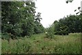
Lashley Wood
Lashley Wood http://www.wildessex.net/sites/Lashley%20Wood.htm has no indication that there is public access or even any paths to get in to it. Maybe the public access agreement that funded the planting has expired?
Image: © Glyn Baker
Taken: 10 Aug 2013
0.21 miles
4

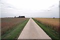
Footpath to Lashley Hall
The farm drive to Image is a public footpath
Image: © Glyn Baker
Taken: 10 Aug 2013
0.22 miles
5
The Way to Lashley Hall
The farm road to Image is a public footpath
Image: © Glyn Baker
Taken: 10 Aug 2013
0.24 miles
6
Ripening Rape on Lashley Hall Farm
Not quite ready for harvest
Image: © Glyn Baker
Taken: 10 Aug 2013
0.24 miles
7
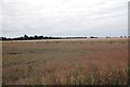
Field Near Lashley Hall
The wheat field in the background is very close to harvest.
Image: © Glyn Baker
Taken: 10 Aug 2013
0.24 miles