IMAGES TAKEN NEAR TO
Stebbing, DUNMOW, CM6 3BN
Introduction
This page details the photographs taken nearby to CM6 3BN by members of the Geograph project.
The Geograph project started in 2005 with the aim of publishing, organising and preserving representative images for every square kilometre of Great Britain, Ireland and the Isle of Man.

There are currently over 7.5m images from over14,400 individuals and you can help contribute to the project by visiting https://www.geograph.org.uk
Image Map
Images are licensed for reuse under creativecommons.org/licenses/by-sa/2.0
Notes
- Clicking on the map will re-center to the selected point.
- The higher the marker number, the further away the image location is from the centre of the postcode.
Image Listing (4 Images Found)
Images are licensed for reuse under creativecommons.org/licenses/by-sa/2.0
Image
Details
Distance
1
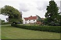
Lashley Hall
A magnificent old farm house
Image: © Glyn Baker
Taken: 10 Aug 2013
0.03 miles
2
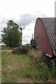
Coms Mast on Lashley Hall Farm
Farmers now further serve the community by providing sites for mobile phone masts. I wonder how many protests about erection of masts are organised by mobile phone?!! I also wonder how many people are alive today because the first responders were alerted moments after an accident by a witness using mobile phone?
Image: © Glyn Baker
Taken: 10 Aug 2013
0.07 miles
3
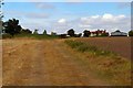
Footpath to Lashley Hall
This is the footpath that runs from the B1057 in Stebbing to Lashley Hall
Image: © Glyn Baker
Taken: 22 Sep 2007
0.20 miles
4
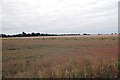
Field Near Lashley Hall
The wheat field in the background is very close to harvest.
Image: © Glyn Baker
Taken: 10 Aug 2013
0.25 miles