IMAGES TAKEN NEAR TO
St. Edmunds Lane, DUNMOW, CM6 3AT
Introduction
This page details the photographs taken nearby to St. Edmunds Lane, CM6 3AT by members of the Geograph project.
The Geograph project started in 2005 with the aim of publishing, organising and preserving representative images for every square kilometre of Great Britain, Ireland and the Isle of Man.

There are currently over 7.5m images from over14,400 individuals and you can help contribute to the project by visiting https://www.geograph.org.uk
Image Map
Images are licensed for reuse under creativecommons.org/licenses/by-sa/2.0
Notes
- Clicking on the map will re-center to the selected point.
- The higher the marker number, the further away the image location is from the centre of the postcode.
Image Listing (14 Images Found)
Images are licensed for reuse under creativecommons.org/licenses/by-sa/2.0
Image
Details
Distance
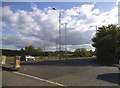
1
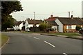
Saint Edmunds Lane, Great Dunmow, Essex
Image: © Robert Edwards
Taken: 13 Sep 2006
0.06 miles
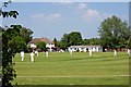
3
Chelmer Valley Park
Summer Holidays at last for the youngsters playing in the country park. The waymark is for the Image https://www.ldwa.org.uk/ldp/members/show_path.php?path_name=Saffron+Trail long distance path which runs through it.
Image: © Glyn Baker
Taken: 23 Jul 2015
0.10 miles
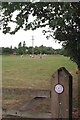
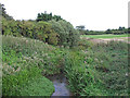
4
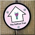
Saffron Trail
The Waymark for the long distance path from Southend Pier to Saffron Walden https://www.ldwa.org.uk/ldp/members/show_path.php?path_name=Saffron+Trail
Image: © Glyn Baker
Taken: 23 Jul 2015
0.10 miles
5
Junction on Braintree Road, Great Dunmow
Image: © David Howard
Taken: 18 Apr 2017
0.12 miles
6
River Chelmer, Great Dunmow
As seen from the bridge crossing the river at Braintree Road, Great Dunmow.
Image: © Roger Jones
Taken: 1 Sep 2013
0.14 miles
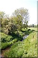
7
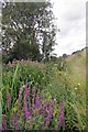
Chelmer & Purple Loosestrife
The native Loosestrife is having to compete with the garden escapee Himalayan balsam. Britain's native White-clawed crayfish are thought to survive in this stretch of the Chelmer.
Image: © Glyn Baker
Taken: 23 Jul 2015
0.14 miles
8
River Chelmer at Great Dunmow
Public areas on both banks, wild on the left, tamed on the right.
Image: © Robin Webster
Taken: 11 Jan 2015
0.14 miles
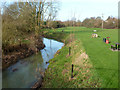
9
River Chelmer
View up-river from the bridge on Braintree Road
Image: © John Myers
Taken: 18 May 2014
0.14 miles
10
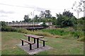
Braintree Rd Bridge
The picnic table is in Chelmer Valley Park, which is managed by Dunmow Council
Image: © Glyn Baker
Taken: 23 Jul 2015
0.14 miles