IMAGES TAKEN NEAR TO
Braintree Road, DUNMOW, CM6 3AP
Introduction
This page details the photographs taken nearby to Braintree Road, CM6 3AP by members of the Geograph project.
The Geograph project started in 2005 with the aim of publishing, organising and preserving representative images for every square kilometre of Great Britain, Ireland and the Isle of Man.

There are currently over 7.5m images from over14,400 individuals and you can help contribute to the project by visiting https://www.geograph.org.uk
Image Map
Images are licensed for reuse under creativecommons.org/licenses/by-sa/2.0
Notes
- Clicking on the map will re-center to the selected point.
- The higher the marker number, the further away the image location is from the centre of the postcode.
Image Listing (2 Images Found)
Images are licensed for reuse under creativecommons.org/licenses/by-sa/2.0
Image
Details
Distance
1
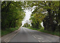
Braintree Road
The straightness of the old Roman Road is evident.
Image: © Julian P Guffogg
Taken: 8 May 2015
0.06 miles
2
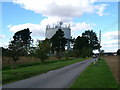
Water Tower at near Homelye Farm, Dunmow, Essex
Water Tower on the A1256 (formerly the old A120). In flat areas water towers are used to create water pressure in the mains. This service road leads to the B&B at Homelye Farm.
Image: © Brenda Howard
Taken: 17 Sep 2005
0.24 miles