IMAGES TAKEN NEAR TO
Folly Mill Lane, DUNMOW, CM6 2NW
Introduction
This page details the photographs taken nearby to Folly Mill Lane, CM6 2NW by members of the Geograph project.
The Geograph project started in 2005 with the aim of publishing, organising and preserving representative images for every square kilometre of Great Britain, Ireland and the Isle of Man.

There are currently over 7.5m images from over14,400 individuals and you can help contribute to the project by visiting https://www.geograph.org.uk
Image Map
Images are licensed for reuse under creativecommons.org/licenses/by-sa/2.0
Notes
- Clicking on the map will re-center to the selected point.
- The higher the marker number, the further away the image location is from the centre of the postcode.
Image Listing (6 Images Found)
Images are licensed for reuse under creativecommons.org/licenses/by-sa/2.0
Image
Details
Distance
1
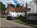
Follymill Farmhouse, Thaxted (listed building)
Late C16 house, extended in early C17. Timber framed and plastered.Timber frame exposed externally. 2 storeys. Centre range C16. West wing C17, and modern jettied east wing
List entry Number: 1112154 http://list.english-heritage.org.uk/resultsingle.aspx?uid=1112154
Image: © Roger Jones
Taken: 11 Aug 2013
0.05 miles
2
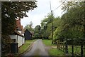
Folly Mill Lane
Quiet lane crossing the River Chelmer by Folly Mill House
Image: © Chris Heaton
Taken: 19 Oct 2023
0.06 miles
3
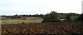
Hammer Hill - Stanbrook
Hammer Hill is a highpoint overlooking the River Chelmer valley
Image: © David Morgan
Taken: 12 Nov 2006
0.13 miles
4
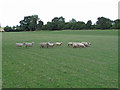
Sheep in field, near Follymill, Thaxted
Image: © Roger Jones
Taken: 11 Aug 2013
0.20 miles
5
Folly Mill Lane
The west end of the lane at its junction with the lane from Tilty.
Image: © Trevor Harris
Taken: 5 Apr 2014
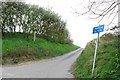
0.25 miles
6
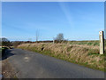
Roadside nature reserve
On Folly Mill Lane.
Image: © Robin Webster
Taken: 11 Jan 2015
0.25 miles