IMAGES TAKEN NEAR TO
Monk Street, DUNMOW, CM6 2NS
Introduction
This page details the photographs taken nearby to Monk Street, CM6 2NS by members of the Geograph project.
The Geograph project started in 2005 with the aim of publishing, organising and preserving representative images for every square kilometre of Great Britain, Ireland and the Isle of Man.

There are currently over 7.5m images from over14,400 individuals and you can help contribute to the project by visiting https://www.geograph.org.uk
Image Map
Images are licensed for reuse under creativecommons.org/licenses/by-sa/2.0
Notes
- Clicking on the map will re-center to the selected point.
- The higher the marker number, the further away the image location is from the centre of the postcode.
Image Listing (1 Images Found)
Images are licensed for reuse under creativecommons.org/licenses/by-sa/2.0
Image
Details
Distance
1
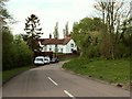
Monk Street Farm, Monk Street, Essex
Monk Street is a small hamlet just south of Thaxted and lies just west of the B184 road. This picture shows Monk Street Farm, which shows a date of 1754.
Image: © Robert Edwards
Taken: 5 May 2006
0.18 miles