IMAGES TAKEN NEAR TO
Elers Way, DUNMOW, CM6 2FN
Introduction
This page details the photographs taken nearby to Elers Way, CM6 2FN by members of the Geograph project.
The Geograph project started in 2005 with the aim of publishing, organising and preserving representative images for every square kilometre of Great Britain, Ireland and the Isle of Man.

There are currently over 7.5m images from over14,400 individuals and you can help contribute to the project by visiting https://www.geograph.org.uk
Image Map
Images are licensed for reuse under creativecommons.org/licenses/by-sa/2.0
Notes
- Clicking on the map will re-center to the selected point.
- The higher the marker number, the further away the image location is from the centre of the postcode.
Image Listing (7 Images Found)
Images are licensed for reuse under creativecommons.org/licenses/by-sa/2.0
Image
Details
Distance
1
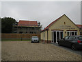
Linden Homes marketing suite
For the Meadow Gardens development on the edge of Thaxted.
Image: © Hugh Venables
Taken: 23 Aug 2017
0.02 miles
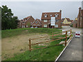
3
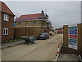
Meadow Gardens, Thaxted
Ongoing housing development on the edge of Thaxted.
Image: © Hugh Venables
Taken: 23 Aug 2017
0.05 miles
4
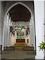
Inside church of Thaxted
A foreigner visiting Thaxted on an early Sunday morning
Image: © Jaap Jongejan
Taken: 29 Apr 2007
0.13 miles
5
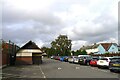
Margaret Street car park and public convenience, Thaxted
Free parking and free toilets in this attractive town.
Image: © Tim Heaton
Taken: 19 Oct 2023
0.22 miles
6
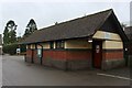
Public Convenience at Margaret Street Car Park in Thaxted
Tidy and well maintained facilities in this ancient town
Image: © Chris Heaton
Taken: 19 Oct 2023
0.24 miles