IMAGES TAKEN NEAR TO
Grange Green, DUNMOW, CM6 2EH
Introduction
This page details the photographs taken nearby to Grange Green, CM6 2EH by members of the Geograph project.
The Geograph project started in 2005 with the aim of publishing, organising and preserving representative images for every square kilometre of Great Britain, Ireland and the Isle of Man.

There are currently over 7.5m images from over14,400 individuals and you can help contribute to the project by visiting https://www.geograph.org.uk
Image Map
Images are licensed for reuse under creativecommons.org/licenses/by-sa/2.0
Notes
- Clicking on the map will re-center to the selected point.
- The higher the marker number, the further away the image location is from the centre of the postcode.
Image Listing (8 Images Found)
Images are licensed for reuse under creativecommons.org/licenses/by-sa/2.0
Image
Details
Distance
1
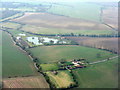
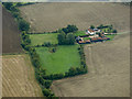
Coldarbour Farm
A farm near Broxted, and ponds marked on the map as a fishery.
Image: © M J Richardson
Taken: 1 Mar 2019
0.05 miles
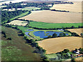
2
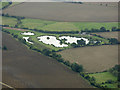
Dairymeads Fishery from the air
Viewed from a Stansted bound flight from Glasgow.
Image: © Thomas Nugent
Taken: 27 Sep 2016
0.12 miles
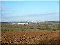
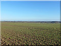
3
Coldarbour Farm from the air
Viewed from a Stansted bound flight from Glasgow.
Image: © Thomas Nugent
Taken: 27 Sep 2016
0.13 miles
5
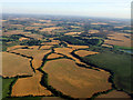
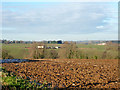
Essex from the air
Harvest time around Coldarbour Farm on the approach to Stansted from Prague.
Image: © Thomas Nugent
Taken: 7 Sep 2012
0.19 miles
6
Coldarbour Farm from the air
Viewed from a flight from Prague on approach to Stansted.
Image: © Thomas Nugent
Taken: 7 Sep 2012
0.19 miles