IMAGES TAKEN NEAR TO
Duton Hill, DUNMOW, CM6 2DT
Introduction
This page details the photographs taken nearby to CM6 2DT by members of the Geograph project.
The Geograph project started in 2005 with the aim of publishing, organising and preserving representative images for every square kilometre of Great Britain, Ireland and the Isle of Man.

There are currently over 7.5m images from over14,400 individuals and you can help contribute to the project by visiting https://www.geograph.org.uk
Image Map
Images are licensed for reuse under creativecommons.org/licenses/by-sa/2.0
Notes
- Clicking on the map will re-center to the selected point.
- The higher the marker number, the further away the image location is from the centre of the postcode.
Image Listing (6 Images Found)
Images are licensed for reuse under creativecommons.org/licenses/by-sa/2.0
Image
Details
Distance
1
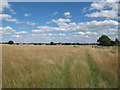
Footpath through meadow, Duton Hill
Public footpath through grassland at Dutton Hill in the parish of Great Easton.
Image: © Roger Jones
Taken: 11 Aug 2013
0.08 miles
2
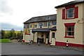
The Three Horseshoes, Duton Hill
An attractive country pub with a great array of old signs.
Image: © Trevor Harris
Taken: 5 Apr 2014
0.14 miles
4
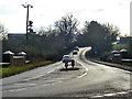
B184 at Barnard's Bridge
Impressive bridge parapets for a rather small branch of the River Chelmer.
Image: © Robin Webster
Taken: 30 Dec 2014
0.24 miles
5
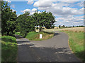
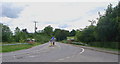
Farm track junction, Duton Hill
A public footpath runs along the track to the left, note the ripe wheat in the field on the right of the picture.
Just north of Dutton Hill in the parish of Great Easton.
Image: © Roger Jones
Taken: 11 Aug 2013
0.25 miles