IMAGES TAKEN NEAR TO
Cherry Green, DUNMOW, CM6 2DD
Introduction
This page details the photographs taken nearby to Cherry Green, CM6 2DD by members of the Geograph project.
The Geograph project started in 2005 with the aim of publishing, organising and preserving representative images for every square kilometre of Great Britain, Ireland and the Isle of Man.

There are currently over 7.5m images from over14,400 individuals and you can help contribute to the project by visiting https://www.geograph.org.uk
Image Map
Images are licensed for reuse under creativecommons.org/licenses/by-sa/2.0
Notes
- Clicking on the map will re-center to the selected point.
- The higher the marker number, the further away the image location is from the centre of the postcode.
Image Listing (5 Images Found)
Images are licensed for reuse under creativecommons.org/licenses/by-sa/2.0
Image
Details
Distance
1
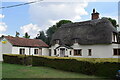
The Old Forge, Cherry Green
With the out building displaying the flag in support of Ukraine.
Image: © Trevor Harris
Taken: 2 Sep 2022
0.02 miles
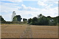
2
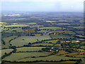
Cherry Green from the air
The microwave tower at Henham Image can be seen in the centre. Viewed from a flight on final approach to Stansted.
Image: © Thomas Nugent
Taken: 12 Jun 2011
0.09 miles
3
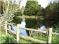
The pond at Cherry Green Farm
This old fish pond sits to one side of the farm's entrance. The farm is at the end of Cheery Greens only road. I better mention that the old OS map shows the village as Chaureth Green.
Image: © David Morgan
Taken: 12 Nov 2006
0.09 miles
4
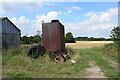
Tank and tyres at Cherry Green Farm
Looking north out of part of the farmyard.
Image: © Trevor Harris
Taken: 2 Sep 2022
0.19 miles
5
Footpath approaching Cherry Green Farm
The path leads from Hamperden End southwards to Cherry Green.
Image: © Trevor Harris
Taken: 2 Sep 2022
0.20 miles