IMAGES TAKEN NEAR TO
Broxted, DUNMOW, CM6 2DA
Introduction
This page details the photographs taken nearby to CM6 2DA by members of the Geograph project.
The Geograph project started in 2005 with the aim of publishing, organising and preserving representative images for every square kilometre of Great Britain, Ireland and the Isle of Man.

There are currently over 7.5m images from over14,400 individuals and you can help contribute to the project by visiting https://www.geograph.org.uk
Image Map
Images are licensed for reuse under creativecommons.org/licenses/by-sa/2.0
Notes
- Clicking on the map will re-center to the selected point.
- The higher the marker number, the further away the image location is from the centre of the postcode.
Image Listing (7 Images Found)
Images are licensed for reuse under creativecommons.org/licenses/by-sa/2.0
Image
Details
Distance
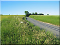
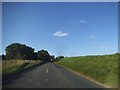
1
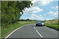
B1051 towards Thaxted
This section is not at all straight.
Image: © Robin Webster
Taken: 12 Jul 2020
0.12 miles
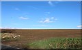
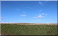
3
Field edge at Chaureth Hall Farm
The broad uncultivated strip separates the road and a field of barley.
Image: © John Allan
Taken: 16 Jun 2010
0.17 miles
6
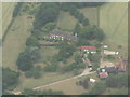
Chickney Halls
Two halls and a listed barn and granary.
Image: © M J Richardson
Taken: 5 Jul 2018
0.24 miles
7
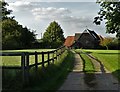
At Chickney
The track leads to former farm buildings to the rear of Chickney Hall.
Image: © Neil Theasby
Taken: 25 Aug 2017
0.25 miles