IMAGES TAKEN NEAR TO
Godfrey Way, DUNMOW, CM6 2AY
Introduction
This page details the photographs taken nearby to Godfrey Way, CM6 2AY by members of the Geograph project.
The Geograph project started in 2005 with the aim of publishing, organising and preserving representative images for every square kilometre of Great Britain, Ireland and the Isle of Man.

There are currently over 7.5m images from over14,400 individuals and you can help contribute to the project by visiting https://www.geograph.org.uk
Image Map
Images are licensed for reuse under creativecommons.org/licenses/by-sa/2.0
Notes
- Clicking on the map will re-center to the selected point.
- The higher the marker number, the further away the image location is from the centre of the postcode.
Image Listing (14 Images Found)
Images are licensed for reuse under creativecommons.org/licenses/by-sa/2.0
Image
Details
Distance
1
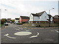
Godfrey Way, Great Dunmow
A mini-roundabout at the end of Godfrey Way. The road leads into a modern housing development.
Image: © Malc McDonald
Taken: 29 Oct 2022
0.09 miles
2
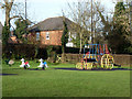
Agricultural play apparatus, Great Dunmow
Horses and a tractor.
Image: © Robin Webster
Taken: 11 Jan 2015
0.10 miles
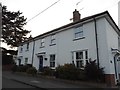
3
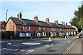
Pleasant Terrace, The Causeway, Great Dunmow
Some intricate brickwork here, particularly on the end wall, which must have kept the bricklayer on his toes. The name and the date 1893 are on a stone probably planned to be in the centre of the front, but the far end has signs of being added as an afterthought. Its end wall has no diamond pattern, just simple lines of white bricks. Initials 'C.W.' are on the centre stone.
Image: © Robin Webster
Taken: 11 Jan 2015
0.11 miles
4
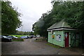
Public convenience, Dunmow Recreation Ground
Image: © Tim Heaton
Taken: 19 Oct 2023
0.14 miles
7
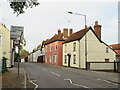
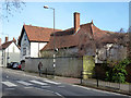
North Street, Great Dunmow
North Street in the town of Great Dunmow in north Essex. This road is on the route of the B1008.
Image: © Malc McDonald
Taken: 29 Oct 2022
0.21 miles
8
The King's Head (closed), Great Dunmow
This pub and hotel on North Street has been closed and boarded up for some years, with signs of abandoned or postponed building work. It is grade II listed, the oldest parts from the 15th century.
Image: © Robin Webster
Taken: 11 Jan 2015
0.23 miles
9
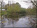
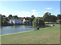
Parsonage Downs Pond, Great Dunmow
One of the ponds at Parsonage Downs, Great Dunmow.
Image: © Roger Jones
Taken: 16 Nov 2013
0.23 miles