IMAGES TAKEN NEAR TO
Newton Hall Chase, DUNMOW, CM6 2AR
Introduction
This page details the photographs taken nearby to Newton Hall Chase, CM6 2AR by members of the Geograph project.
The Geograph project started in 2005 with the aim of publishing, organising and preserving representative images for every square kilometre of Great Britain, Ireland and the Isle of Man.

There are currently over 7.5m images from over14,400 individuals and you can help contribute to the project by visiting https://www.geograph.org.uk
Image Map
Images are licensed for reuse under creativecommons.org/licenses/by-sa/2.0
Notes
- Clicking on the map will re-center to the selected point.
- The higher the marker number, the further away the image location is from the centre of the postcode.
Image Listing (6 Images Found)
Images are licensed for reuse under creativecommons.org/licenses/by-sa/2.0
Image
Details
Distance
1
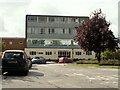
Helena Romanes School, Great Dunmow, Essex
Image: © Robert Edwards
Taken: 21 Aug 2006
0.10 miles
2
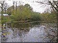
Parsonage Downs Pond, Great Dunmow
One of the ponds at Parsonage Downs, Great Dunmow.
Image: © Roger Jones
Taken: 16 Nov 2013
0.18 miles
3
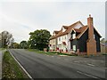
Beaumont Hill, Great Dunmow
Newly-built houses on Beaumont Hill, in the town of Great Dunmow.
Beaumont Hill is on the route of the B1008 road.
Image: © Malc McDonald
Taken: 29 Oct 2022
0.20 miles
4
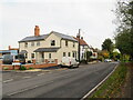
The Old Cricketers, Great Dunmow
The Old Cricketers is a former pub in Great Dunmow which has been converted into housing. When it was a pub, it was named The Cricketers. The road passing the pub forms part of the route of the B1008.
Image: © Malc McDonald
Taken: 29 Oct 2022
0.21 miles
5
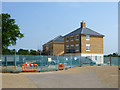
New houses, Great Dunmow
The recent residential enlargement of Great Dunmow to the north-west spreads further north.
Image: © Robin Webster
Taken: 7 Jun 2016
0.21 miles
6
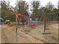
Enclosed footpath, Great Dunmow
From the map (2013) I was expecting a walk through a rural landscape, but found myself in the middle of a large construction site. The public footpath here is clearly demarcated between these security barriers.
Image: © Roger Jones
Taken: 16 Nov 2013
0.23 miles