IMAGES TAKEN NEAR TO
Chequers Lane, DUNMOW, CM6 1ZF
Introduction
This page details the photographs taken nearby to Chequers Lane, CM6 1ZF by members of the Geograph project.
The Geograph project started in 2005 with the aim of publishing, organising and preserving representative images for every square kilometre of Great Britain, Ireland and the Isle of Man.

There are currently over 7.5m images from over14,400 individuals and you can help contribute to the project by visiting https://www.geograph.org.uk
Image Map
Images are licensed for reuse under creativecommons.org/licenses/by-sa/2.0
Notes
- Clicking on the map will re-center to the selected point.
- The higher the marker number, the further away the image location is from the centre of the postcode.
Image Listing (60 Images Found)
Images are licensed for reuse under creativecommons.org/licenses/by-sa/2.0
Image
Details
Distance
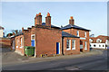
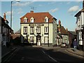
1

Rood End House, Great Dunmow
Now offices on Stortford Road. A grade II listed early 19th century building in need of external redecoration.
Image: © Robin Webster
Taken: 11 Jan 2015
0.03 miles
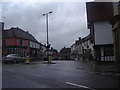
2
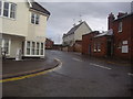
Chequers Lane, Dunmow
Forest Court on the left appears to be a new build rather than a renovation, the builders were certainly still working on it on Streetview.
Image: © David Howard
Taken: 25 Apr 2012
0.03 miles
3
Premises on Stortford Road, Great Dunmow
The central building is Sweetland's, a butchers. A grade II listed building, 16th century or earlier. At least when listed (in 1984), there was a slaughterhouse on the premises - there is a through way to a rear yard with associated buildings.
Image: © Robin Webster
Taken: 11 Jan 2015
0.03 miles
4
Figurewise Health and Beauty Centre, Great Dunmow
Housed in a grade II listed building, grouped with the block out of sight to the right for listing purposes. 16th century or earlier with early 19th century refronting.
Image: © Robin Webster
Taken: 11 Jan 2015
0.04 miles
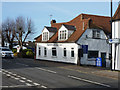
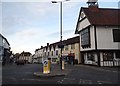
5
Former police station, Great Dunmow
A view of what is now 'Uttlesford Community Hub' according to the sign display, 'Uttlesford Voluntary and Community Centre' according to their web site. The police station was erected in 1842 and was claimed to be the oldest police station in Essex. The police moved to new premises in 2008.
Image: © Robin Webster
Taken: 11 Jan 2015
0.04 miles
6
Market Place, Dunmow
At the junction with High Street
Image: © David Howard
Taken: 25 Apr 2012
0.06 miles
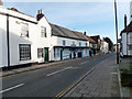
8
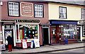
Shops in Great Dunmow
Willett's newsagents on High Street, with its traditional shop front and signage, is something of a Dunmow institution.
Image: © Stephen McKay
Taken: Unknown
0.07 miles
9
'The Starr' hotel
This hotel is a timber-framed building that dates back to the 17th century.
Image: © Robert Edwards
Taken: 15 Jan 2007
0.07 miles
10

Old town hall, Great Dunmow
The old town hall building in Great Dunmow. A Grade II listed building.
Image: © Pebble
Taken: 28 Dec 2021
0.08 miles