IMAGES TAKEN NEAR TO
Mill Court, DUNMOW, CM6 1ST
Introduction
This page details the photographs taken nearby to Mill Court, CM6 1ST by members of the Geograph project.
The Geograph project started in 2005 with the aim of publishing, organising and preserving representative images for every square kilometre of Great Britain, Ireland and the Isle of Man.

There are currently over 7.5m images from over14,400 individuals and you can help contribute to the project by visiting https://www.geograph.org.uk
Image Map
Images are licensed for reuse under creativecommons.org/licenses/by-sa/2.0
Notes
- Clicking on the map will re-center to the selected point.
- The higher the marker number, the further away the image location is from the centre of the postcode.
Image Listing (20 Images Found)
Images are licensed for reuse under creativecommons.org/licenses/by-sa/2.0
Image
Details
Distance
3

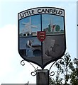
House on Stortford Road, Little Canfield
Image: © David Howard
Taken: 19 Nov 2017
0.04 miles
4
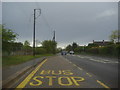
Bus stop on Stortford Road, Little Canfield
Image: © David Howard
Taken: 25 Apr 2012
0.06 miles
5
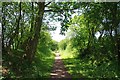
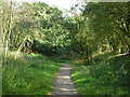
Cutting Approaching Little Canfield
Part of the Flitch Way Country Park
Image: © Glyn Baker
Taken: 29 Jun 2019
0.11 miles
6
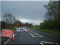
Road works on Stortford Road, Little Canfield
Image: © David Howard
Taken: 25 Apr 2012
0.14 miles
7
Former Bishop's Stortford - Braintree railway
Now a foot and cycleway, the railway used to pass under High Cross Lane straight ahead, but the bridge has been filled in. The path deviates north about 90 m to cross the road where it drops to a lower level, the road still passing over an apparently undiminished hump. Summer vegetation made it hard to see exactly what had happened to the bridge, but there was no obvious masonry left either at track level or road level.
Image: © Robin Webster
Taken: 27 Sep 2014
0.14 miles
8
Bridge over a former railway on High Cross Lane West
Although the Flitch Way follows the route of the old railway line, it doesn't go under the road here - a detour has to be made to cross the road a little to the north of the bridge.
Image: © Trevor Harris
Taken: 11 Jun 2022
0.15 miles
9
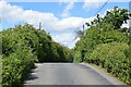
High Cross Lane West, near Great Dunmow
High Cross Lane West is a minor road in north Essex countryside. Here, it climbs to cross over a railway line. However, the railway closed in 1952 and has been dismantled. The railway route is now a traffic-free walking and cycling path, the Flitch Way. The path to the left of the road, leading to the former railway route, is part of the Flitch Way.
Image: © Malc McDonald
Taken: 29 Oct 2022
0.15 miles
10
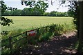
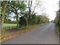
Flitch Way and Ripening Barley
Here the right of way deviates from the course of the old railway.
Image: © Glyn Baker
Taken: 29 Jun 2019
0.16 miles