IMAGES TAKEN NEAR TO
White Roding, DUNMOW, CM6 1RX
Introduction
This page details the photographs taken nearby to CM6 1RX by members of the Geograph project.
The Geograph project started in 2005 with the aim of publishing, organising and preserving representative images for every square kilometre of Great Britain, Ireland and the Isle of Man.

There are currently over 7.5m images from over14,400 individuals and you can help contribute to the project by visiting https://www.geograph.org.uk
Image Map
Images are licensed for reuse under creativecommons.org/licenses/by-sa/2.0
Notes
- Clicking on the map will re-center to the selected point.
- The higher the marker number, the further away the image location is from the centre of the postcode.
Image Listing (3 Images Found)
Images are licensed for reuse under creativecommons.org/licenses/by-sa/2.0
Image
Details
Distance
1
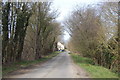
Lane north of Lucas Farm
Looking towards the house called Norrington.
Image: © Trevor Harris
Taken: 7 Apr 2013
0.02 miles
2
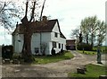
Walker's Farm, Aythorpe Roding, Essex
Walker's Farm lies to the west of Aythorpe Roding on a minor road.
Image: © Robert Edwards
Taken: 30 Apr 2006
0.18 miles
3

Lane near Walkers Farm
The lane doesn't seem to have a name.
Image: © Robin Webster
Taken: 30 Jun 2013
0.19 miles