IMAGES TAKEN NEAR TO
Matching Lane, DUNMOW, CM6 1RP
Introduction
This page details the photographs taken nearby to Matching Lane, CM6 1RP by members of the Geograph project.
The Geograph project started in 2005 with the aim of publishing, organising and preserving representative images for every square kilometre of Great Britain, Ireland and the Isle of Man.

There are currently over 7.5m images from over14,400 individuals and you can help contribute to the project by visiting https://www.geograph.org.uk
Image Map
Images are licensed for reuse under creativecommons.org/licenses/by-sa/2.0
Notes
- Clicking on the map will re-center to the selected point.
- The higher the marker number, the further away the image location is from the centre of the postcode.
Image Listing (3 Images Found)
Images are licensed for reuse under creativecommons.org/licenses/by-sa/2.0
Image
Details
Distance
1
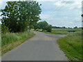
Matching Lane - Cooks Farm Lane junction
The near Matching Lane was the old route from Matching, severed when RAF Matching was built. To the right Cooks Farm Lane was a new road starting a diversion.
Image: © Robin Webster
Taken: 30 Jun 2013
0.12 miles
2
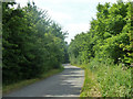
Matching Lane
Formerly a through route before RAF Matching was built in WWII, now only accessing Waterloo Farmhouse and Cottage.
Image: © Robin Webster
Taken: 30 Jun 2013
0.17 miles
3
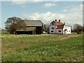
Snow's Farm, near White Roding, Essex
Image: © Robert Edwards
Taken: 17 Apr 2006
0.18 miles