IMAGES TAKEN NEAR TO
Church Lane, DUNMOW, CM6 1RN
Introduction
This page details the photographs taken nearby to Church Lane, CM6 1RN by members of the Geograph project.
The Geograph project started in 2005 with the aim of publishing, organising and preserving representative images for every square kilometre of Great Britain, Ireland and the Isle of Man.

There are currently over 7.5m images from over14,400 individuals and you can help contribute to the project by visiting https://www.geograph.org.uk
Image Map
Images are licensed for reuse under creativecommons.org/licenses/by-sa/2.0
Notes
- Clicking on the map will re-center to the selected point.
- The higher the marker number, the further away the image location is from the centre of the postcode.
Image Listing (8 Images Found)
Images are licensed for reuse under creativecommons.org/licenses/by-sa/2.0
Image
Details
Distance
1
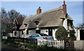
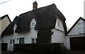
Moncks Green Cottage, White Roding
Grade II Thatched hipped roof 17 Century Cottage
Image: © Lee Holmes
Taken: 25 Mar 2012
0.05 miles
2
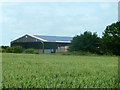
Barn, Mascallsbury Farm
Looking across a field of wheat.
Image: © Robin Webster
Taken: 30 Jun 2013
0.14 miles
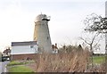
4
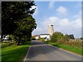
Windmill, White Roding
Built in C19 to replace an earlier mill blown down in 1877. It was in use until 1931. See http://www.britishlistedbuildings.co.uk/en-120603-windmill-white-roothing-essex#.VhgVmPlViko for entry in British Listed Buildings.
Image: © Bikeboy
Taken: 3 Oct 2015
0.20 miles
5

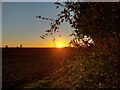
White Roding from the air
Also known as White Roothing.
Image: © Thomas Nugent
Taken: 14 Sep 2015
0.21 miles
6
Little Timbers, White Roding
Grade II, 17C Cottage, March 2012
Image: © Lee Holmes
Taken: 25 Mar 2012
0.23 miles
7
Old Mill, White Roding
Sailess mill on the edge of the village
Image: © MJ Reilly
Taken: 16 Mar 2009
0.23 miles
8
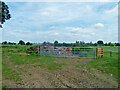
New gates and a heap
The field was being cleaned up and fenced, the lack of a fence to the left was because a new cattle shed was to be built there.
Image: © Robin Webster
Taken: 30 Jun 2013
0.24 miles