IMAGES TAKEN NEAR TO
Marks Hall Lane, DUNMOW, CM6 1QT
Introduction
This page details the photographs taken nearby to Marks Hall Lane, CM6 1QT by members of the Geograph project.
The Geograph project started in 2005 with the aim of publishing, organising and preserving representative images for every square kilometre of Great Britain, Ireland and the Isle of Man.

There are currently over 7.5m images from over14,400 individuals and you can help contribute to the project by visiting https://www.geograph.org.uk
Image Map
Images are licensed for reuse under creativecommons.org/licenses/by-sa/2.0
Notes
- Clicking on the map will re-center to the selected point.
- The higher the marker number, the further away the image location is from the centre of the postcode.
Image Listing (8 Images Found)
Images are licensed for reuse under creativecommons.org/licenses/by-sa/2.0
Image
Details
Distance
1
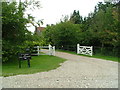
Reid Rooms, Marks Hall Lane
My brother-in-law just got married here!
Image: © Nick Mutton 01329 000000
Taken: 28 Jun 2007
0.06 miles
2
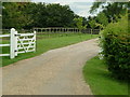
Reid Rooms, Marks Hall Lane (Main Entrance)
This is the main entrance to the Reid Rooms which is a converted farm.
Image: © Nick Mutton 01329 000000
Taken: 28 Jun 2007
0.06 miles
3
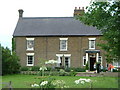
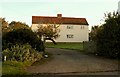
Reid Rooms, Marks Hall Lane (Old farmhouse)
This is the old farmhouse which used to be connected to Marks Hall Farm.
Image: © Nick Mutton 01329 000000
Taken: 28 Jun 2007
0.09 miles
6
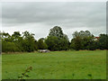
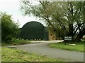
Old pig shelter
Judging by the state of the field by Grey's Cottage, pigs have not been here for a while.
Image: © Robin Webster
Taken: 8 Sep 2011
0.20 miles