IMAGES TAKEN NEAR TO
Ongar Road, DUNMOW, CM6 1QS
Introduction
This page details the photographs taken nearby to Ongar Road, CM6 1QS by members of the Geograph project.
The Geograph project started in 2005 with the aim of publishing, organising and preserving representative images for every square kilometre of Great Britain, Ireland and the Isle of Man.

There are currently over 7.5m images from over14,400 individuals and you can help contribute to the project by visiting https://www.geograph.org.uk
Image Map
Images are licensed for reuse under creativecommons.org/licenses/by-sa/2.0
Notes
- Clicking on the map will re-center to the selected point.
- The higher the marker number, the further away the image location is from the centre of the postcode.
Image Listing (4 Images Found)
Images are licensed for reuse under creativecommons.org/licenses/by-sa/2.0
Image
Details
Distance
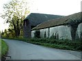
1
Ongar Road at Waples Mill Farm
At the junction with bridleway PROW 186_25.
See the other side of the barn at Image
Image: © Glyn Baker
Taken: 17 May 2020
0.03 miles
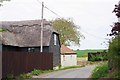
2
Waples Mill Farm - derelict
A pleasant spot by the River Roding - what a waste.
Image: © Robin Webster
Taken: 27 Sep 2014
0.04 miles
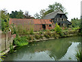
3
Waples Mill Farm Revitalised
The new owners of Waples Mill will never have any problems with spare cash bothering them! In 2014 the mill was derelict see Image The track is bridleway PROW 186_25.
Image: © Glyn Baker
Taken: 17 May 2020
0.04 miles