IMAGES TAKEN NEAR TO
Aythorpe Roding, DUNMOW, CM6 1PD
Introduction
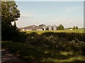
This page details the photographs taken nearby to CM6 1PD by members of the Geograph project.
The Geograph project started in 2005 with the aim of publishing, organising and preserving representative images for every square kilometre of Great Britain, Ireland and the Isle of Man.

There are currently over 7.5m images from over14,400 individuals and you can help contribute to the project by visiting https://www.geograph.org.uk
Image Map
Images are licensed for reuse under creativecommons.org/licenses/by-sa/2.0
Notes
- Clicking on the map will re-center to the selected point.
- The higher the marker number, the further away the image location is from the centre of the postcode.
Image Listing (2 Images Found)
Images are licensed for reuse under creativecommons.org/licenses/by-sa/2.0
Image
Details
Distance
2
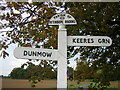
Direction Sign ? Signpost near Bigods Farm in Aythorpe Roding
Located on a grass triangle in the centre of a T junction southwest of Bigods Farm in Aythorpe Roding parish. 3 arms and half-moon finial. The finial is a 'recycled' cast iron one and would have been saved from a Maldon Iron Works iron fingerpost.
Milestone Society National ID: EX_TL5915
Image: © John V Nicholls
Taken: 26 Sep 2004
0.14 miles